Geological Origins of Canada’s Cordilleran Mountain System
The Cordilleran Mountain System, extending the length of the west margin of the North American continent, consists of numerous separate and distinct mountain ranges, is host to much of the continent’s mineral and energy natural resources, is the source of much of our freshwater the last bastion of all of our sub-arctic glaciers, and constitutes one of the continents last great wilderness regions. But why the Cordillera exists at all remains a difficult question to answer. It is understood that plate tectonics plays a key role in the formation of mountains. Typically, one continent crashes into another resulting in a thickened, mountainous welt of buoyant continental crust. The ongoing collision of India with the south margin of Asia giving rise to the Himalayan mountains and the Tibetan plateau is a modern example of this process. So what collision gave rise to the Cordillera?
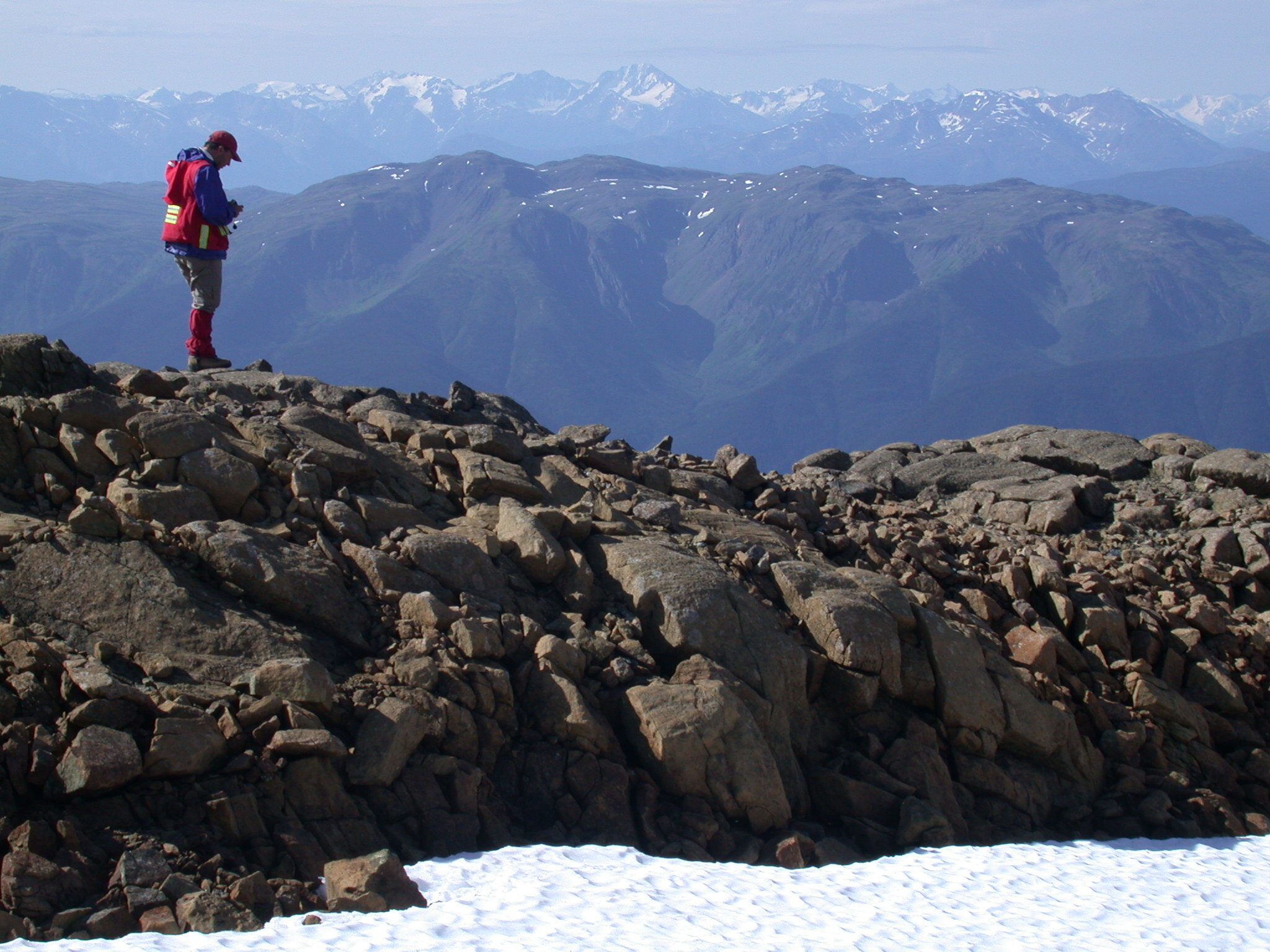
Looking west across the Nakina mountain range of north-central British Columbia toward the snow-covered Coast Ranges of B.C. and the Alaskan pan-handle in distance. Rocks in the foreground being examined by Dante Canil (geology professor, Univ. of Victoria). Photo: S.T. Johnston
Continents collide when oceanic plates separating them subduct (sinking down into the Earth’s mantle) resulting in ocean closure. In the case of India and Asia, the Indian continent was attached to an oceanic plate that subducted beneath Asia, pulling the Indian continent into and beneath Asia. During collision, the Asian continental crust slid up and over the Indian continental crust, giving rise to a mountain system (the Himalaya) that advanced over and helped push down the incoming Indian plate. As a result, the mountains of the Himalaya consist of (from south to north, and highly simplified) crust and sediment scraped from and pushed back over the leading edge of the Indian continent; a belt of basalts and oceanic rocks referred to as a suture (the Indus Tsang-Po suture), which is a remnant of the ocean that formerly separated the two continents, and, north of the suture, deformed Asian crust (Figure 1). The bulk of the Indian continental crust south of the mountains lies buried by kilometres of sediment eroded from the high-standing mountains, forming what we refer to as a syn-collisional foreland basin south of the mountain system.

Figure 1. A simplified block model through the Himalaya (after Frisch et al., 2011) viewed looking east (south to left) showing the Himalaya as a product of collision of India with Asia after closure of an ocean that formerly separated the two continents by subduction of the oceanic lithosphere (depicted here as breaking off and sinking into the mantle). Reference: Frisch, W., Meschede, M. and Blakey, R. Plate Tectonics: Continental Drift and Mountain Building. Springer, Berlin, Heidelberg, 214 (2011).
Applying this ‘template’ to the Cordillera, it appears that our mountain system resulted from the closure of an ocean basin that separated a North American continent that extended west to the current Alberta-B.C. border, from a slender ‘Cordilleran’ continent to the west.[1] In this model, the Himalaya are represented by the Rocky Mountains, India by the North American continent, and Asia by a Cordilleran continent that underpins BC and Yukon (Figure 2). The Rockies consist of North American crust pushed back to the east over itself, implying that, like India, North America was attached to an oceanic plate that subducted to the west.[2]
This model makes three testable predictions: (1) North American crust east of the Rockies should be buried beneath kilometres of ‘syn-collisional’ sediments that were derived from mountains during collision; (2) there should be a ‘suture’ to the west of the Rockies that marks the site of the closed ocean; and (3) the Cordilleran continental crust to the west of the suture should be different and distinguishable from North American crust to the east. Only one of these predictions is fully borne out. North American crust east of the Rockies is characterized by an immense stack of Late Cretaceous sedimentary strata. Near the mountain front, these clastic (sandstone and mudstone) sedimentary sequences and interbedded coal layers are more than four kilometres thick (Figure 2). They thin to the east, are ‘syn-collisional,’ and define a large ‘foreland basin’ similar to the one that is forming south of the Himalaya today. But traversing west through the Rockies looking for a suture of basalts and oceanic deposits has proved fruitless. Because there is no discernable suture, it is debatable whether or not there is a ‘Cordilleran’ continental domain west of the Rockies that is stratigraphically and geologically distinguishable from truly ‘North American’ crust to the east (Figure 2). And while paleontological and paleomagnetic data suggest that most of B.C. and Yukon lay 2,000 to 3,000 kilometres south of North America as recently as seventy million years ago,[3] most Cordilleran researchers argue that there is no suture, that ‘bona fide’ North American crust extends west to or near to the current west coast, and that there was no continental collision.[4]
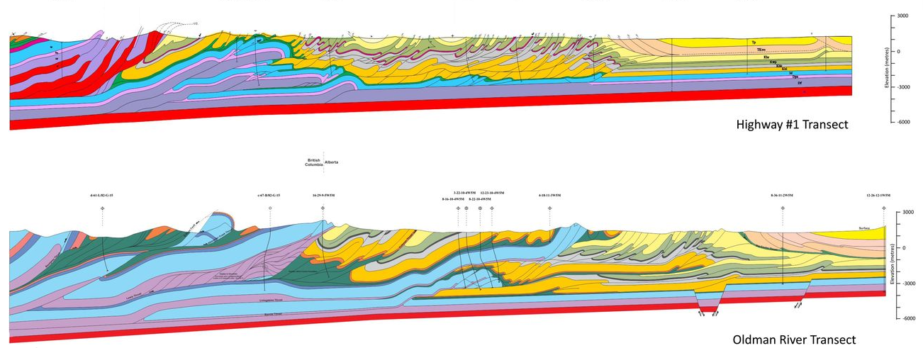
Figure 2. Two cross-sections of the Rocky Mountains (after MacKay, 2015) viewed looking north (west to the left). North American Precambrian basement (in red) is continuous at depth. Overlying Precambrian to Cretaceous sedimentary strata has been faulted, stacked up and pushed eastward. Deformation can be interpreted to have resulted from collision of North America beneath a Cordilleran continent subsequent to closure of an ocean basin separating the two (like the Indian continent colliding with Asia) or as a product of interaction with oceanic lithosphere subducting beneath the west margin of North America. Reference: MacKay, P. The role of fluid pressure in contractional systems: examples from the Southern Canadian Rocky Mountains. In: Richards, F. L., Richardson, N. J., Rippington, S. J., Wilson, R. W. & Bond, C. E. (eds). Industrial Structural Geology: Principles, Techniques and Integration. Geological Society. London, Special Publications, 421, 69–82 (2015).
If there was no continental collision, then why do we have a Cordilleran mountain system at all?[5] Perhaps the answer lies with another mountain system to the south: the Andes. This mountain system, including the Altiplano plateau, is the second-highest mountain system on Earth, next only to the Himalaya/Tibetan plateau. And yet, the Andean (west) margin of South America is characterized by the subduction of an oceanic plate (the Nazca) beneath the continent. There is no ‘continental collision’ suggesting that mountain systems can be generated by subduction. And yet subduction, because it consists of the gravitational sinking of the oceanic plate, usually results in extension, subsidence, basin development and inundation of the adjacent continental plate – the exact opposite of mountains. So why subduction should give rise to mountain systems at some points in Earth history (the Cordillera in the Cretaceous, and the Andes today) while generally having the opposite effect, remains a major unresolved question in understanding plate tectonics, the workings of the solid Earth, and the deep time evolution of the Earth System.
Author Bio
Stephen is the Chair of the Department of Earth and Atmospheric Sciences at the University of Alberta. His research concerns the origins and tectonic significance of mountain belts, both ancient and still forming, of western and Arctic North America, South America, Melanesia, China, southern Africa and Europe.
References
[1]Johnston, S.T. The Cordilleran Ribbon Continent of North America. Annual Review of Earth and Planetary Sciences, 36, 495-530 (2008).
[2]Ibid.
[3]Enkin, R.J. Paleomagnetism and the case for Baja British Columbia. Paleogeography of the North American Cordillera: evidence for and against large-scale displacements. Edited by JW Haggart, RJ Enkin, and JWH Monger. Geological Association of Canada, Special Paper, 46, 233-253 (2006).
[4]Price, R.A. Cordilleran Tectonics and the Evolution of the Western Canada Sedimentary Basin. Geological Atlas of the Western Canada Sedimentary Basin, eds. G.D. Mossop and I. Shetsen (Canadian Society of Petroleum Geologists and Alberta Research Council, 1994). URL https://ags.aer.ca/publications/chapter-2-cordilleran-tectonics.htm
[5]English, J.M. and S.T. Johnston. The Laramide orogeny: What were the driving forces? International Geology Review 46, 9, 833-838 (2004).